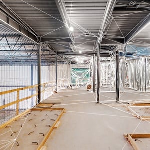
3D SCANNING
CUSHING'S 3D SCANNING SERVICES
HAVE THE CUSHING TEAM SCAN YOUR SPACE WITH OUR 3D LASER SCANNERS FOR EFFICIENT PLANNING, DESIGN, AND RENOVATIONS.
3D Scanning...
3D laser scanning has revolutionized the construction and real estate industries by providing a precise and comprehensive way to capture and analyze spatial data. This technology, whether through Matterport or Trimble scanning, offers numerous benefits that streamline processes, enhance accuracy, and save time and money.
Laser scanning has revolutionized the construction and real estate industries by providing a precise and comprehensive way to capture and analyze spatial data. Our LiDAR scanning services capture detailed and precise 3D representations of physical spaces to provide a comprehensive view of your project. With cutting-edge technology, we capture existing conditions quickly and convert them into reliable 3D models, CAD files, or point clouds, ensuring you have the exact measurements needed for confident decision-making.
Scans can be integrated into BIM modeling services, allowing you to be able to significantly enhance your project outcome.
3D SCANNING FOR CONSTRUCTION AND REAL ESTATE
3D scanning captures high-resolution, accurate representations of buildings and construction sites. This level of detail is crucial for identifying potential issues early in the project, reducing errors, and ensuring that every aspect of the structure is correctly documented.
Creating as-built documentation is significantly faster and more precise with 3D scanning. This ensures that any changes made during construction are accurately recorded, providing a reliable reference for future renovations, maintenance, or legal purposes.
The detailed data from 3D scans can be easily shared among project stakeholders, including architects, engineers, and contractors. This fosters better collaboration, allowing teams to visualize the project in its entirety and make informed decisions collectively.
3D scanning reduces the need for manual measurements and repeated site visits, saving considerable time and labor costs. The ability to detect and address issues early also minimizes the risk of costly rework and delays
For real estate management, 3D scanning provides accurate floor plans and models, which are essential for space planning, asset management, and maintenance scheduling. This leads to more efficient use of space and resources.
Maintaining a digital archive of 3D scans creates a permanent, detailed record of the building's condition at various stages. This is invaluable for future assessments, renovations, or transactions, providing a clear history of the property's development.
What is the relationship between LiDAR and Point Cloud Scanning ?
This is a great question! Point cloud data is the term used to refer to the data points collected for a given geographical area, terrain, building, or space. A LiDAR point cloud dataset is created when an area is laser scanned using LiDAR, or light detection and ranging.
BENEFITS OF 3D SCANNING FOR Architectural and Engineering design
1. Efficiently creates accurate CAD Floorplans and BIM Models
2. Improves Project Collaboration
3. Enhances collaboration and communication by adding existing conditions details
4. Saves time required to send team members on site, avoiding re-visits.
Owner, Construction, and Gaphics Teams Optimize communication using 3D scans
Sloomoo Institute
In this fast-tracked River North project, interactive 3D scans allowed stakeholders to explore the space virtually, from across the country, coordinate with the boots on the ground, and save thousands of dollars in changes and travel expenses.
- Contractors coordinate with mechanical design team in real time, and are able to locate outlets that had been covered by drywall inadvertently, saving thousands.
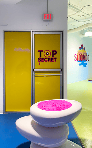
- NYC-based owners were able to work with our graphic imaging team virtually to approve placement of wall graphics and signage in their new Chicago location. The design team was able to hold meetings with the construction team REMOTELY!
- Cushing’s 3D scans of Sloomoo’s finished space allowed the owner to do a walk through remotely, 48 hours prior to the Grand Opening, saving an extra day of travel!
“David Parkes and other members of the Cushing team took the time to understand our laser scanning needs and provided a service and product above my expectations.
I plan to use them for another project I have in their area in the future.”