3D REALITY CAPTURE FOR ARCHITECTURE & ENGINEERING
3D LASER SCANNING FOR ARCHITECTS, ENGINEERS AND DESIGN CONSULTANTS
EXPERIENCE LASER SCANNING FOR DESIGN
3D Scanning...
Accurate measurements are the foundation of successful architectural projects. Cushing’s 3D laser scanning services provide highly detailed, precise site data to streamline your design process. Whether you're working on renovations, historical preservation, or new construction, our laser scanning solutions help eliminate guesswork, reduce costly errors, and improve project efficiency.
With cutting-edge technology, we capture existing conditions quickly and convert them into reliable 3D models, CAD files, or point clouds, ensuring you have the exact measurements needed for confident decision-making. Enhance accuracy, save time, and elevate your architectural projects with Cushing’s professional laser scanning services.
Revolutionize Your Projects with LiDAR Scanning Technology
Design firms need 3D scans to capture exact existing conditions when assigned to re-design space. Real Estate is expensive, and every misuse of space costs several hundred dollars. LiDAR scanning technology is transforming the AEC industry, providing highly accurate, detailed, and rapid site data.
Explore the numerous benefits of LiDAR scanning for AEC professionals and how it can elevate your projects to new heights.
Benefits of LiDAR Scanning in Architectural Design
LiDAR scanning captures environments with millimeter-level accuracy, ensuring that every detail is documented. This precision is critical for creating reliable design plans, minimizing errors, and reducing the need for rework. Architects, engineers, and construction professionals can rely on LiDAR data to make informed decisions and achieve better project outcomes.
LiDAR data seamlessly integrates with Building Information Modeling (BIM) and Geographic Information Systems (GIS), enhancing the accuracy and utility of these tools. By incorporating precise LiDAR data into BIM models, AEC professionals can improve design accuracy, conduct clash detection, and streamline construction workflows. GIS integration allows for better spatial analysis and planning.
By reducing the need for multiple site visits and minimizing errors, LiDAR scanning contributes to sustainability efforts and cost savings. The efficiency of LiDAR scanning means fewer resources are expended on rework and site documentation, resulting in a more cost-effective and environmentally friendly approach to project management.
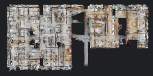
What’s the alternative to scanning?
Firms send two-to-three young architects to an unbuilt, or recently demolished space, and take measurements using tapes and tools. This is not just one or two measurements. They are responsible to cover every aspect of mechanicals and support columns. Many times, items in the mechanicals and HVAC system come into play.
Avoid rework and Change orders and save your client from headaches and cost over-runs.
Adaptive re-use as a growing concern in Commercial real estate
LiDAR scanning captures detailed information about existing structures, including hidden elements such as pipes and wiring. This is critical for planning renovations and retrofits, as it provides a complete understanding of the current state of the building.
Use point cloud data to integrate new designs with existing structures seamlessly. This ensures that renovations and additions are accurately aligned with the existing building, reducing potential issues during construction.
Document and preserve historical buildings by creating detailed 3D models. This data is invaluable for restoration projects, ensuring that any interventions are respectful of the building's heritage.
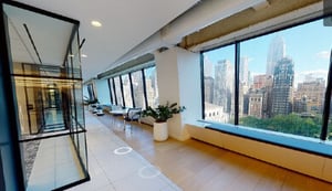
Real Estate brokers love 3D VizBuilt scanning
virtual tours allow them to show off their beautiful office via email, to encourage a physical tour of potential renters to see the new space! Also if a landlord or developer is responsible for getting renovations completed, also known as “base-building” work before a tenant moves in, laser scanning can uncover anything that to be addressed prior to the work.
Benefits of LiDAR Scanning in Engineering Design
LiDAR scanning provides accurate and comprehensive site surveys, capturing every detail of the existing environment. This data is crucial for understanding site conditions, conducting feasibility studies, and planning the design layout.
Create detailed and precise 3D models of existing structures and landscapes. These models are invaluable for engineers and designers to visualize projects, identify potential challenges, and ensure that new designs integrate seamlessly with existing structural and mechanical elements.
Integrating point cloud data with BIM models allows for clash detection and coordination between different building systems. This helps to identify and resolve conflicts early in the design phase, reducing costly rework during construction.
