

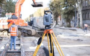
LIDAR SCANNING TO A POINT CLOUD
CUSHING'S LIDAR SCANNING AND BIM MODELING SERVICES
Capture existing conditions with state-of-the-art accuracy through Cushing’s point cloud scanning and modeling services.
For more information, see...
Whether you are in the planning stages of a new construction, managing an ongoing project, or looking to renovate an existing structure, Cushing's LiDAR scanning and BIM modeling services can significantly enhance your project outcomes. Our technology provides a comprehensive view of your project, enabling you to make informed decisions, reduce errors, and optimize efficiency. Explore how Cushing's services can help you deliver exceptional results and set new standards of excellence in the AEC industry.
What is LiDAR Scanning?
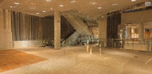
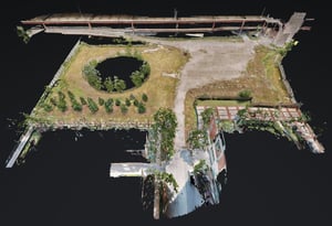
LiDAR scanning is a remote sensing method that uses laser light to measure distances and create detailed, three-dimensional representations of the environment. This technology captures millions of data points, known as a point cloud, which can be used to generate accurate 3D models of physical spaces. LiDAR scanning is particularly effective for large-scale and complex projects, offering unparalleled precision and efficiency.
WHAT IS A POINT CLOUD?
Essentially, laser light is used to capture 3D representations of a building or construction site, in the form of point clouds. Point clouds typically represent the external surface of an object.

When to choose LiDAR scanning over Matterport, photogrammetry.
While both technologies hold an important place in the built industries, photogrammetry is widely used to offer quick, accurate views of existing conditions, including easy-to-use, built-in measuring tools for anything from pre-con analysis, remote group meetings and even bidding. Advanced LiDAR is typically a more accurate measuring details down to a higher level of tolerance and accuracy for building a model, especially for unique spaces that will require that higher level of accuracy: Laboratories, Data Centers, offices with heavy mechanicals, or even commercial space with several floor-to-ceiling glass walls for offices of conference space.
"There is no more costly change order than those resulting from a poor FFFL report."
FFFL Floor Flatness and Floor Level reports
We recommend the highest level of detail found in LiDAR technology. 3D LiDAR scanners are an ideal tool used to capture a Floor Flatness, Floor Level report. We take a basis point, typically off the threshold of an elevator entry to that floor, and run a report against that stationary point, using an algorithm that reveals the +/- derivation off that stationary point, providing the bidding contractor to estimate material usage, labor and call out Risk measures that will place them in front of an educated client, to educate them on the concerns of their well in advance of construction.
Avoid rework and change orders with 3D scanning and FFFL reports.
ACCURATELY AND COMPLETELY DOCUMENT EXISTING CONDITIONS OF A FACILITY PRIOR TO THE START OF ANY RENOVATION PROJECT
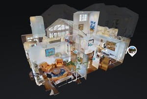
Use 3D scanning to quickly and accurately capture the existing conditions of a building. Create as–built Revit models or Autocad files to begin your design.
Real Estate agents can show off their beautiful office via email, to encourage a physical tour of potential renters to see the new space!
When a landlord is responsible for renovations or “base-building” work for a tenant, 3D scanning will uncover areas that need addressing upfront.
EXISTING CONDITIONS FOR ADAPTIVE REUSE
Adaptive reuse continues to trend as more cities preserve and adapt their historic buildings. Young companies such as start-ups want to move in, incorporate history and maintain it. But what happens when that start-up has ideas for an ultra-modern design and it is hard to tell if the existing infrastructure can support the changes?
Scanning can provide 3D views designers can use to capture century-old architecture and manage the risk inherent in upgrading spaces. Any developer would say that changes identified before construction are much less expensive than ones you discover in the middle of the project
From general contractors to engineers, 3d scanning empowers professionals in the business of building. You can make decisions in real-time from remote locations, with access to these files. Let’s work together.